
具体描述
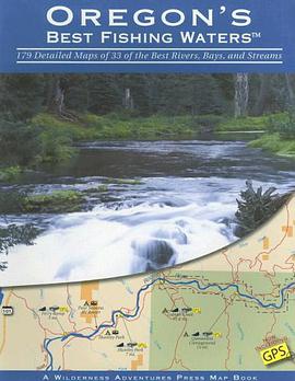
This is the most comprehensive angling map ever created for Oregon's rivers and streams. There are a total of 179 full color 8-1/2 x11 detailed maps, that show access sites, boat ramps, campgrounds, roads and trails. All access sites are clearly marked with GPS coordinates. River miles, public and private land, dams, rapids, and a wealth of other useful information for anglers is included. Thirty-three of Oregon's best waters are mapped, including the Deschutes, Elk, Fall, Grande Ronde, Hood, John Day, Klamath, McKenzie, Nehalem, Rogue, Sandy, Tillamook Bay, Chetco, Clackamas, Willamette, Umpqua, and others. Public land is clearly identified in color, and every possible access or state lease is easy to find with just a glance. Oregon's Best Fishing Waters is a must have for any avid fisherman.
作者简介
目录信息
读后感
评分
评分
评分
评分
用户评价
相关图书


本站所有内容均为互联网搜索引擎提供的公开搜索信息,本站不存储任何数据与内容,任何内容与数据均与本站无关,如有需要请联系相关搜索引擎包括但不限于百度,google,bing,sogou 等
© 2026 book.wenda123.org All Rights Reserved. 图书目录大全 版权所有