
具體描述
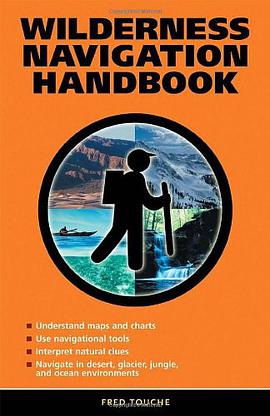
Designed for both land and water use, this comprehensive guide helps unlock the complexity of map and chart reading as it relates to navigation. Beginning with detailed technical descriptions of the tools of navigation-a compass, an altimeter, a GPS system, and a sextant-this handbook shows how to use these tools either individually or in combination with each other to navigate any area. Factors that cause tools and techniques to fail are discussed, such as why an altimeter often shows the wrong elevation, a GPS position is sometimes off track, and the sun often points in an unexpected direction. Twenty-one real-life scenarios provide practical wisdom for even the most intrepid navigator. Specific information on using the moon for directions and the stars for position, measuring boiling water temperature for elevation, map projections, map datums, great circle routes, and the UTM/UPS grid system is included.
作者簡介
目錄資訊
讀後感
評分
評分
評分
評分
用戶評價
相關圖書


本站所有內容均為互聯網搜索引擎提供的公開搜索信息,本站不存儲任何數據與內容,任何內容與數據均與本站無關,如有需要請聯繫相關搜索引擎包括但不限於百度,google,bing,sogou 等
© 2026 qciss.net All Rights Reserved. 小哈圖書下載中心 版权所有